An aerial view of a narrow peninsula with dramatic snow-capped mountains

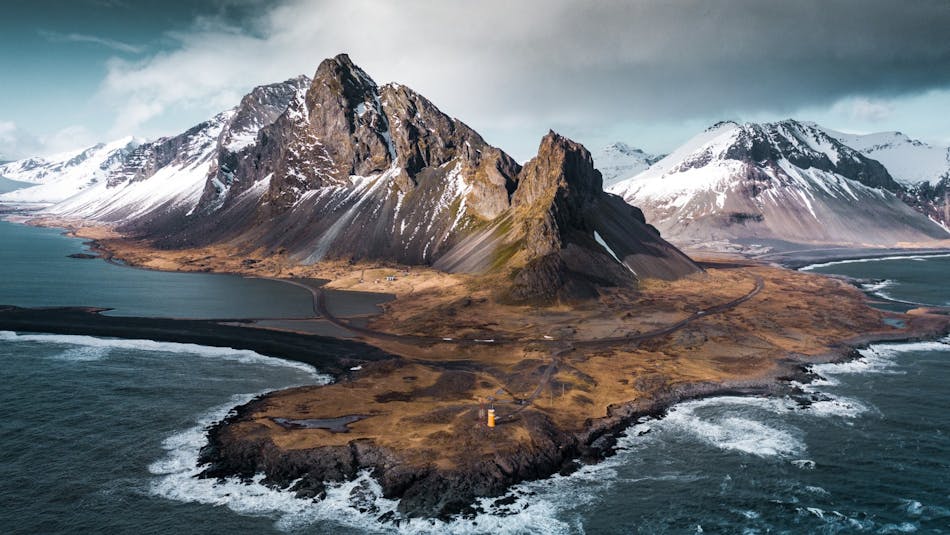
Eystrahorn: A testament to nature's alchemy in East Iceland, showcasing some of the country's most awe-inspiring geological wonders.

Nature's Gems: 5 geosites in East Iceland

East Iceland offers an array of geological features where it is possible to peek into the magma chambers of extinct central volcanoes and explore the colorful minerals formed deep within the Earth's crust.

At the heart of East Iceland's geology are the Tertiary basalt formations, which date back approximately 15 million years. These formations are the result of extensive volcanic activity during the Tertiary period, creating layers of basalt that have been sculpted by erosion into strikingly beautiful landscapes with deep fjords and rugged mountains.

The region is renowned for its vibrant minerals, and a visit to Petra's Stone & Mineral Collection in Stöðvarfjörður and Auðun's Rock Collection in Djúpivogur is highly recommended to see samples of these natural wonders that hobbyists in the area have collected. Another must-stop is The Breiðdalssetur Center in Breiðdalsvík, housed in the Old Cooperative Merchant House. It offers a deep dive into the geology of East Iceland with educational exhibits and even a play corner for children focused on geology. It highlights the region's geological significance and showcases the pioneering work of George P. L. Walker, a leading 20th-century volcanologist. Walker's extensive research in Breiðdalsvík and the East Fjords has been crucial for understanding Iceland's geological landscape.

Glacial activity has played a significant role in shaping the region's topography. During the last Ice Age, glaciers carved deep fjords into the coastline and shaped the valley floors, leaving behind a landscape that is both dramatic and diverse. The retreat of these glaciers has also exposed ancient bedrock, revealing a geological history that spans millions of years.

We have hand-picked five locations of particular interest but recommend traveling the area at a slow pace also to discover other wonders of East Iceland.

A spotted rock with a lighthouse and dramatic mountain peak in clouds in the back

1. Hvalnes at Eystrahorn: A Peek Inside a Magma Chamber

Location: Hvalnes is a tiny peninsula situated in Iceland's southeastern corner. It marks the divide between South and East Iceland along Ring Road no. 1.

Hvalnes, meaning "whale peninsula," is a stunningly picturesque coastal spot that boasts the historic Hvalnes Lighthouse. Set against the dramatic backdrop of the horned mountains of Eystrahorn and Vestrahorn, it overlooks the sea lagoon Lónsfjörður, known for its extensive black beach.

The area's geological foundation reveals the eroded and exposed inner workings of extinct central volcanoes. Notably, Mt. Eystrahorn is composed of gabbro, a type of intrusive igneous rock formed from basalt magma. This magma intruded into the volcanic roots and underwent a slow cooling process deep within the volcano. This gradual cooling allowed time for minerals to grow large, resulting in the formation of gabbro with its distinguishably large crystals.

The bedrock around the lighthouse on the shore is particularly fascinating to explore. It encapsulates a history of intense heat within a magma chamber, where various types of magma and crystal mush welded together, creating intricate and beautiful patterns in the rocks. These formations offer a tangible connection to the dynamic volcanic processes that shaped this region.

A farmstead on a rugged shore

2. Teigarhorn: Natures Gems Revealed

Location: Teigarhorn is located just 3 km from Djúpivogur town, adjacent to Ring Road No. 1.

! Please note that Teigarhorn Zeolites are protected, and the removal of rocks is strictly forbidden.

Teigarhorn is a renowned nature reserve in the East Fjords of Iceland, near the town of Djúpivogur. It is most famous for being one of the most significant zeolite locations in the world and for its historical significance. A short hike along the marked path to the shore is perfect for exploring rocks and historical remnants.

Zeolites are a group of secondary minerals, meaning they grow after the initial rock has formed. Teigarhorn’s zeolites, formed through the alteration of volcanic rock by hydrothermal fluids, showcase a stunning variety of shapes and sizes, from radiating crystals of scolecite to the blade-like formations of heulandite and the clustered crystals of stilbite.

This remarkable location provides a rare glimpse into the volcanic processes that dominated Iceland’s geological past. Approximately 8.5 to 10 million years ago, the region was at the center of the volcanic zone and characterized by intense volcanic activity forming basalt layers. Since it has drifted away from the volcanic zone further east with the Eurasian tectonic plate. The layers buried deep in the strata then underwent significant alteration. The presence of hydrothermal fluids, interacting with the basalt, facilitated the growth of zeolite crystals within the rock’s cavities. Two distinct belts of zeolites at Teigarhorn, the mesolite-scolecite and heulandite-stilbite belts, illustrate the layered complexity of these formations. During the last Ice Age, the glaciers carved approximately 1,5 km of the strata off and exposed the once buried zeolite belts.

A few people exploring a blue cliff

3. Blábjörg: The Earth's Natural Welding Workshop

Location: The Blábjörg headland is easily accessible on the north side of the Beru-fjord, just a few steps down on the shore from the parking by the main road. 

Blábjörg is a small seacliff or headland on the north shore of Berufjord in East Iceland. It is part of a formation called the Berufjörður Tuff, a significant geological phenomenon formed through violent volcanic processes about 9-10 million years ago. The Berufjörður Tuff is a classic example of ignimbrite, a solidified pyroclastic flow that occurs during colossal explosive eruptions. The uniqueness of Blábjörg lies in its composition primarily of welded rhyolite ash, with interspersed basalt fragments, showcasing the diversity of magma involved in its formation.

The creation of Blábjörg began with a massive eruption at a central volcano, ejecting voluminous rhyolite magma into the atmosphere. This magma, upon cooling, transformed into a dense cloud of ash and pumice. As the eruption cloud became gravitationally unstable, it collapsed, generating a ground-hugging, high-speed pyroclastic flow. This flow, consisting of superheated ash, gas, and volcanic debris, raced across the landscape. Due to the intense heat and the sheer mass of the material, the ash particles welded together upon deposition, forming the compact, solid rock layer observed today.

Over time, geological processes, including deep burial and subsequent exposure by Ice Age glaciers, have altered the ignimbrite, leading to the formation of chlorite minerals within the rock matrix. This mineralization process imparts Blábjörg's characteristic greenish tint. The resulting formation stands as a vivid testament to the dynamic and powerful volcanic forces that have shaped Iceland's landscape.

A closeup of clear white minerals in a dark rock wall

4. Helgustaðanáma: Navigating History with the Iceland Spar Legacy Mine

Location: Helgustaðir quarry is located 5 km east of Eskifjörður town in East Iceland. See the location on a map here.

! Please note that removal of Iceland Spar is forbidden, and the area is a protected nature reserve.

The Helgustaðir quarry is famous for its remarkable deposits of Iceland spar, an exceptionally clear type of calcite mineral.

Iceland spar from Helgustaðir played a crucial role in scientific discoveries and the development of technologies over the centuries. In the 17th century, it was used by the Danish scientist Rasmus Bartholin to discover double refraction, a fundamental property in the study of optics. Later, it contributed to the development of polarizing microscopes and other optical instruments leading to important discoveries in the fields of physics, chemistry, and geology in the 19th and 20th centuries.

Quarrying at Helgustaðir began in the 17th century and continued intermittently until the early 20th century. The spar was highly valued internationally and exported for use in scientific research and precision instruments. Most of the Iceland spar found in museums around the world comes from the Helgustaðir quarry, where some of the largest and clearest specimens of Iceland spar in the world have been discovered.

Today, the Helgustaðir quarry is no longer active, but the site remains a significant part of Iceland's geological and cultural heritage. Visitors can hike up the hill along a 500-meter path with a 60-meter elevation gain to explore the site, where they can observe the minerals in their natural setting and discover the area's history and unique characteristics.

A man standing in a gorge with green river and giant basalt column walls

5. Stuðlagil Canyon: Where Nature Plays with Geometry

Location and access: Stuðlagil Canyon is nestled in East Iceland's Jökuldalur Valley and is accessible via Road 923 (partly gravel road) from Ring Road No. 1. For a detailed description of viewing and hiking options and how to get there check out the official Visit East Iceland website.

Stuðlagil Canyon in East Iceland has recently emerged as a notable geosite, particularly celebrated for its stunning basalt column formations. This canyon, carved by the Jökulsá á Dal river, was relatively unknown until the early 21st century. The Kárahnjúkar Hydropower Plant built in 2007 changed the water flow and sediment load of the former murky glacier river, revealing the stunning basalt columns in the canyon. 

The Stuðlagil canyon's waters, tinted in shades of bluish-green, create a stunning contrast against the basalt columns, making it a truly mesmerizing sight. Like many glacial rivers, Jökla's color and flow vary with the seasons. In spring, as the snow begins to melt and the Hálslón reservoir reaches its capacity in the fall, the river adopts a grey-brown hue. 

Natures Organizers: Columnar Basalt Formation

The basalt columns at Stuðlagil are an excellent example of columnar jointing, showcasing the geometric precision that can occur naturally through volcanic processes. Columnar basalt forms when basalt lava cools and contracts, creating a distinctive pattern of columns. This process begins as the surface of a lava flow cools to solidify at around 1000°C. As cooling continues, the entire mass contracts, generating stress that fractures the rock into a series of vertical cracks. These cracks, or joints, naturally organize into hexagonal patterns, the most efficient shape for minimizing stress across the cooling surface. 

The reason why columns are usually hexagonal is that the hexagon is the polygon closest in shape to a circle that can also fill a plane. Triangles and squares can also fill a plane, but are far from circular in shape; octagons and dodecagons approach the circle but cannot fill a plane. The columns are perpendicular to the cooling front, resulting in vertical structures in flows, horizontal in dikes and radiate from the center in bulbous formations. This is a slow process and for example after the Heimaey eruption in 1973, a 40-meter-thick lava flow took 10 years to cool and joint completely. Over time, erosion can reveal these stunning formations, showcasing nature's geometric artistry in rock.

Hike or stroll the steps? Stuðlagil has two different viewing locations

The canyon's accessibility has improved in recent years, making it accessible year-round. There are two options for exploring the Canyon. On the north side there is about 5-minute walk from the parking area at Grund to viewing platforms for a safe access to the canyon. If you plan to go down into the canyon, you need to walk from another parking area on the land of Klaustursel, which is on the south side of the canyon. There are two options for hiking, one 5 km and the other 10 km (both ways).

Be aware that rocks and stones can be wet or icy and thus slippery, so proceed with caution in the canyon. The nature surrounding Stuðlagil is fragile, and visitors are especially encouraged to respect wildlife and nature. From May 1st to June 10th, numerous pink-footed geese nest in the area, and it's particularly important to stay on marked trails to avoid disturbing the birds.

EXPLORE GEOSITES IN OTHER REGIONS

Nature's Alchemy: 5 geosites in East Iceland