A couple witnessing the start of the Litli-Hrútur eruption in Iceland July 11, 2023. Photo: Thrainn Kolbeinsson

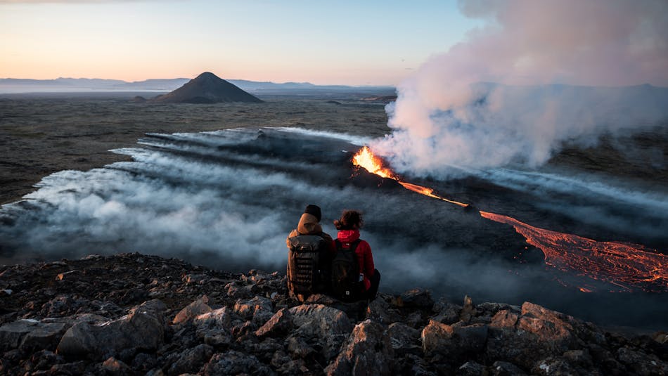
The Reykjanes Peninsula, a geologist's paradise and UNESCO Geopark, showcases the Earth's crust in action and offers geological wonders at every footstep.

Exploring Rumbling Reykjanes: A Journey Through Five Geosites

The Reykjanes Peninsula is a key geological region where the Mid-Atlantic Ocean Ridge is exposed onshore, offering a prime example of divergent plate tectonics and its unique geological features.

A large part of the Reykjanes region has been recognized as a UNESCO Geopark and is characterized by its frequent volcanic events and geothermal features. Among its 55 recognized geosites, the Fagradalsfjall and Svartsengi volcanic systems stand out for erupting regularly since 2021, highlighting the peninsula's dynamic geological environment, where the Earth's crust is actively forming.

Despite the regular occurrence of eruptions, these events are very localized and often short-lived. Therefore, they only affect specific areas without travel restrictions or broader impacts for the rest of Iceland or even the wider peninsula. A dense network of earthquake and GPS monitors watches over the area and Iceland boasts top scientists who monitor the situation and issue timely warnings. Here, you can obtain further information about the eruptions on the Reykjanes Peninsula and their status.

This article focuses on five geosites within Reykjanes Peninsula, each illustrating different aspects of the peninsula's geological makeup and history. These sites provide valuable insights into the processes shaping the Earth's surface, including the role of tectonic movements, volcanic eruptions, and geothermal activity in landscape formation.

Reykjanes's ongoing volcanic activity is an important subject of study, offering opportunities to learn about volcanic behavior, geological hazards, and how communities can adapt to volcanic disturbances. So let's start exploring Reykjanes!

1. The Bridge Between Continents - Where Europe and North America meet

A bridge across a gorge

Location: Road no. 44 and 425 from Keflavík leads to a parking area at the Bridge Between Continents. From here, a 300 m walk on a paved path leads to the bridge itself.

The Bridge Between Continents is a symbolic footbridge over the Álfagjá rift valley in Iceland, which marks the boundary between the Eurasian and North American tectonic plates. Iceland is uniquely positioned on the Mid-Atlantic Ridge, where the two tectonic plates are slowly diverging at an average rate of about 2 centimeters per year. This divergence is part of the process of seafloor spreading that occurs along mid-ocean ridges.

The bridge is often referred to as the "Leif the Lucky Bridge" and is a popular tourist attraction. Visitors can walk across the bridge and stand directly between the two continents, symbolically or even physically straddling the divide. 

While the Bridge Between Continents is more of a symbolic representation, it provides a tangible sense of the geological forces that shape our planet and the slow, ongoing changes that are typically imperceptible in human timescales. It's a reminder of the dynamic nature of Earth's lithosphere and the processes that have been shaping the planet for billions of years.

The formation of a rift valley is a fascinating geological process that can be outlined in several key stages:

Tectonic Forces: Rift valleys form in regions where the Earth's crust is being stretched and thinned. This stretching is caused by tectonic forces associated with the movement of lithospheric plates. In this case, the divergence is related to the activity where two plates are moving away from each other.

Crustal Thinning and Fracturing: As the crust is stretched, it becomes thinner and eventually fractures, creating faults. These faults can be large and extend deep into the Earth's crust. The area between these faults may then start to sink, forming a valley.

Subsidence: The central block of crust, now bounded by faults, begins to subside or sink due to the weight of the overlying rocks and the continued stretching and thinning of the crust. This subsidence creates a linear depression, which is the initial formation of the rift valley.

Volcanic Activity: The thinning of the crust and the pull, can induce magma formation due to pressure release, and allow magma from the mantle to reach the surface more easily, leading to volcanic eruptions along the rift zone. These eruptions can deposit lava in the rift valley.

Continued Divergence and Expansion: As the tectonic plates move apart over time, the rift valley becomes wider and longer. Simultaneously, volcanic activity steadily fills in the valleys, smoothing out the surface.

If you're keen to celebrate your journey between two continents, the Reykjanes Geopark visitor center at the Duus Cultural House offers certificates!

An aerial view of a rugged coastline with steam rising from a power plant nearby

2. Reykjanestá: Greeting the North Atlantic Ocean Ridge Ashore

Location: Reykjanestá is situated at the southwestern tip of the Reykjanes Peninsula via Road no 44 and 425.

Reykjanestá is a geologically significant site renowned for its dramatic coastal scenery, marked by rugged cliffs, crashing waves, and an unparalleled view of the North Atlantic Ocean's might. Basalt formations, including a rift valley, lava fields, crater rows and volcanic ash, dominate the landscape, bearing witness to the area's volcanic origin. This unique location offers a rare chance to witness an oceanic ridge on land, showcasing a phenomenon typically submerged beneath the sea.

Here, the Mid-Ocean Ridge (MOR) ascends from the ocean floor and traverses on land through Iceland and back into the ocean in Öxarfjord in the North. The MOR is the manifestation of the divide between the North American and Eurasian tectonic plates, which are slowly diverging. As these plates drift apart, pressure decreases in the mantle below, reducing the melting point of the rock and generating basalt magma. The magma is less dense than the surrounding rocks and, therefore, rises towards the surface, filling fissures and cracks in the crust that form by the stretching of the plates. Some magma manages to reach the earth's surface, leading lead to eruptions on the ocean floor. This is how all ocean floor crust and mid-ocean ridges are created

So why does the MOR rise from the sea in Iceland? The existence of Iceland above sea level is largely attributed to the action of the Iceland Mantle Plume. Mantle plumes are deep-seated, upward currents of hot rock from within the Earth's mantle-core boundary that ascend toward the crust. These hot material columns are buoyant, rising due to their lower density compared to the surrounding mantle. Upon reaching the relatively cooler regions of the upper mantle and crust, the mantle plume's heat can induce rock melting, generating magma. These areas are called Hot Spots on the surface. There are around 100 of these hot spots known on the planet, and well-known examples are Hawaii and the Galapagos. Without the influence of the mantle plume, Iceland would remain submerged, similar to the remainder of the Mid-Atlantic Ridge.

The most recent volcanic event at Reykjanestá was the Younger-Stampar eruptions in 1230-1240, which was the last series of eruptions in the volcanic episode on the Reykjanes Peninsula 800 years ago, called the Reykjanes fires. This eruption was on a fissure that extended out to the sea and the insides of a half-eroded crater can be explored on the shoreline to the east of the parking area. 

Nearby, lies the intriguing Gunnuhver fumarole and mudpot. According to Icelandic folklore, Gunnuhver is named after Gunna, a notorious female ghost said to have been trapped in the hot springs by a priest centuries ago. Columns of steam in the vicinity signify geothermal energy production at the Reykjanesvirkjun power plant, where steam from the Reykjanes geothermal system powers turbines to generate electricity.

A resort building by a light blue lagoon in a black lava field

3. The Blue Lagoon: Volcanic Wellness In a Dramatic Setting

Location: The Blue Lagoon stands on road no 426 that can be reached form either road no 43 or 425.

! Be aware that volcanic activity has led to temporary closures of the Blue Lagoon and surrounding roads. It's important to verify their status before planning your visit. See road status here.

The Blue Lagoon is a unique phenomenon, where stunning light blue geothermal water fills depressions in a black lava field, and apart from being one of the world's top spa destinations, it is also an interesting geological site. The water has proven to have health benefits, so its popularity is definitely well deserved. The Blue Lagoon can be listed as one of the geological wonders of Iceland, although partly man-made. The geothermal water is exceptionally mineral-rich and comes from nearly 1500 m deep boreholes, similar to those used in the geothermal power plant of Svartsengi next to it. Upon reaching the surface, the water appears milky white, but the presence of diatoms infuses it with a mesmerizing light blue hue. Even if you're not intending to take a dip in the lagoon, the site itself is a must-see and provides a pleasant stopover with good amenities.

The lagoon is cradled within stunning black lava flows, named the Eldvörp lavas, remnants of the Reykjanes Eruptions that occurred between 1210-1240. These flows marked the end of a seismic and volcanic cycle on the Reykjanes Peninsula. Currently, the Peninsula is experiencing a resurgence of activity, including magmatic intrusions at Svartsengi, causing eruptions in Sundhnúksgígar east of the area, and lava flows that have extended down to the roads leading to the Blue Lagoon, resulting in closure and evacuations at the Blue Lagoon. Scientists vigilantly monitor the magmatic movements, ensuring that any potential risks, such as possible eruptions and lava flows, are diligently forecasted and communicated. Therefore, the Blue Lagoon has remained open between volcanic events, allowing people to glimpse Iceland's newest lava fields nearby.

Erupting craters and a partly glowing black field flowing on a snowy surface

From the Fagradalsfjall eruption in 2021. Photo: Thrainn Kolbeinsson

4. Fagradalsfjall

Location: On the local travel web Visit Reykjanes you can find a map of the area showing parking an hiking options as well as practical information on hikes.

! Check the status of eruptions and possible road closures in the area before visiting this site.

Fagradalsfjall Mountain has recently captured the attention of geologists and nature enthusiasts alike. This mountain and its surrounding area serve as a vivid testament to the dynamic geological forces at work beneath Iceland's surface.

Fagradalsfjall is located in an area known for its frequent seismic activity and volcanic eruptions. Opinions vary on whether it constitutes its own volcanic system or is part of the larger Svartsengi system. Despite this debate, the fissure swarm associated with Fagradalsfjall had remained dormant for 6,000 years, making the eruptions that began in 2021 particularly significant. These recent events have reignited interest in the mountain's geological importance, providing a unique chance to directly observe basaltic lava flows as they form and create new land. Such eruptions are a valuable window into understanding volcanic processes and the development of volcanic landscapes.

The geology of Fagradalsfjall is characterized by a combination of ancient lava fields, craters, and newly solidified lava from recent eruptions. The area's volcanic rocks and formations tell a story of repeated eruptions over thousands of years, each layer a chapter in Iceland's volcanic history. The presence of both older, weathered landscapes and fresh lava fields provides a unique contrast, illustrating the ongoing cycle of destruction and creation that defines volcanic regions.

As a geosite, Fagradalsfjall offers a fascinating window into the natural processes that shape our planet. For scientists, it is a natural laboratory for studying volcanic and tectonic processes. For visitors, it provides a spectacular display of nature's power and beauty. The area around Fagradalsfjall is a reminder of the Earth's ever-changing nature and the forces that drive its evolution.

The newly formed lava fields at Fagradalsfjall present an awe-inspiring scene of cooling phenomena, such as sculptural lava ropes, meandering lava channels, craters and vents. Upon closer observation, the careful observer can spot white plagioclase and green olivine crystals nestled within the dark grey matrix of the rock. The rapid cooling of lava can also produce volcanic glass, a shiny and often sharp material that reflects the sudden quenching process.

For those drawn to the wonders of Fagradalsfjall, a selection of hiking trails offers diverse vantage points to appreciate this dynamic geological showcase.

If you're considering a visit to this or similar volcanic sites, it's crucial to arm yourself with the latest safety guidelines and prepare adequately for the terrain and conditions you'll encounter.

A hot spring area with colorful surface and wooden platforms

5. Seltún: The Geothermal Alchemy of Earth's Palette

Location: Seltún is by road no. 427 and here you can find a map and more information for visiting Seltún.

! Never leave the paths and platforms at Seltún or any geothermal areas. The ground might look solid but can be very thin and extremely hot. It's dangerous to step off the path. Be very careful, especially with children.

The Seltún geothermal area, also known as Krýsuvík, is a notable geothermal field or sulfatarra area. The name "sulfatarra" indeed refers to the sulfurous gas emitted by the fumaroles, giving the area a distinctive smell that is often associated with geothermal activity. This area is part of the Krýsuvík volcanic system and is well-known for its hot springs, mud pots, fumaroles, and colorful soils that result from the high-temperature geothermal activity beneath the surface. The last eruption in the Krýsuvík volcanic system was in 1151-1188, and recently, it has been showing signs of unrest again, like its neighboring volcanic systems, Fagradalsfjall and Svartsengi.

The geothermal activity in Seltún results from the presence of a high-temperature zone where heat from a geothermal system at 2-4 km depth rises to the surface and heats rocks and groundwater above that boils and turns to steam. This process alters rocks and minerals and produces mineral deposits with colors ranging from yellow to red and green, which are a characteristic feature of the landscape.

Each hue can indicate key elements involved, showcasing nature's alchemy at work:

Yellow and Bright Yellow: These colors often indicate the presence of elemental sulfur, crystallizing near fumaroles and hot springs where sulfur-rich gases cool. The sulfur deposit was historically mined and used for gunpowder production.

White to Pale Blue: Gypsum (hydrated calcium sulfate) and anhydrite (calcium sulfate) contribute to these lighter shades, formed from sulfuric acid reactions with calcium-bearing materials.

Green and Blue-Green: Copper minerals, when present, can imbue the ground with green hues, while certain silicates and clays may also exhibit various shades of green depending on their composition.

Red, Orange, and Rust: Iron compounds, including oxides and hydroxides, paint the earth in warm tones. These minerals form through the oxidation of iron-bearing fluids or rocks, adding a striking contrast to the landscape.

Bright Whites: Gypsum and anhydrite appear as brilliant white, where silica-rich waters have deposited layers over time.

Pinks and Purples: The less common alunite may add pinkish hues to the sulfatarra palette, indicative of the acidic soils enriched with potassium and aluminum.

Wooden boardwalks and paths have been constructed to allow visitors to explore the area safely without damaging the delicate natural environment or risking injury from the hot and unstable ground. Information signs are typically present to educate visitors on the geothermal processes at work.

Nearby, you can also see Grænavatn, a small but vibrant green crater lake, along with several smaller explosion craters. The larger Kleifarvatn lake, set in a valley between the mountain ridges of Sveifluháls and Brennisteinsfjöll, adds to the scenic variety of the area. These ridges are a phenomenon in fissure eruptions during the last Ice Age. They are predominantly made up of hyaloclastite, or tuff, a brownish type of rock formed from explosive eruptions under ice. Such eruptions, known as phreatomagmatic, happen when ascending magma encounters water and ice, causing powerful explosions that shatter the magma into volcanic ash. This ash accumulates, solidifies, and transforms into rock. Near Kleifarvatn lake, pillow lava formations can also be observed at the bottom, near the lakeshore. These are the result of similar eruptions occurring under higher pressure, leading to their distinctive, bulbous shapes that resemble rose petals.

EXPLORE GEOSITES IN OTHER REGIONS

Exploring Rumbling Reykjanes